When Is the Canyon ACTUALLY Open Again?
tl;dr The app saw the Greek Creek rollover before the highway patrol had dispatched anyone. Then, hours later, it told a few drivers sitting in the queue that the road was open. That’s fixed, and the fix is already live for everyone.
The highway patrol leaving isn’t the road opening.
That sounds obvious written down. It wasn’t obvious to How’s the Canyon on September 22nd, and the app said something it shouldn’t have because of it. Here’s how things unfolded, what the app got right, what it got wrong, and what’s improved now.
The rollover
A little after noon on Tuesday the 22nd, a northbound flatbed hauling hay tipped over on 191 at milepost 59, just north of Greek Creek Campground. It blocked the road completely for part of the afternoon and held it to one alternating lane into the night.
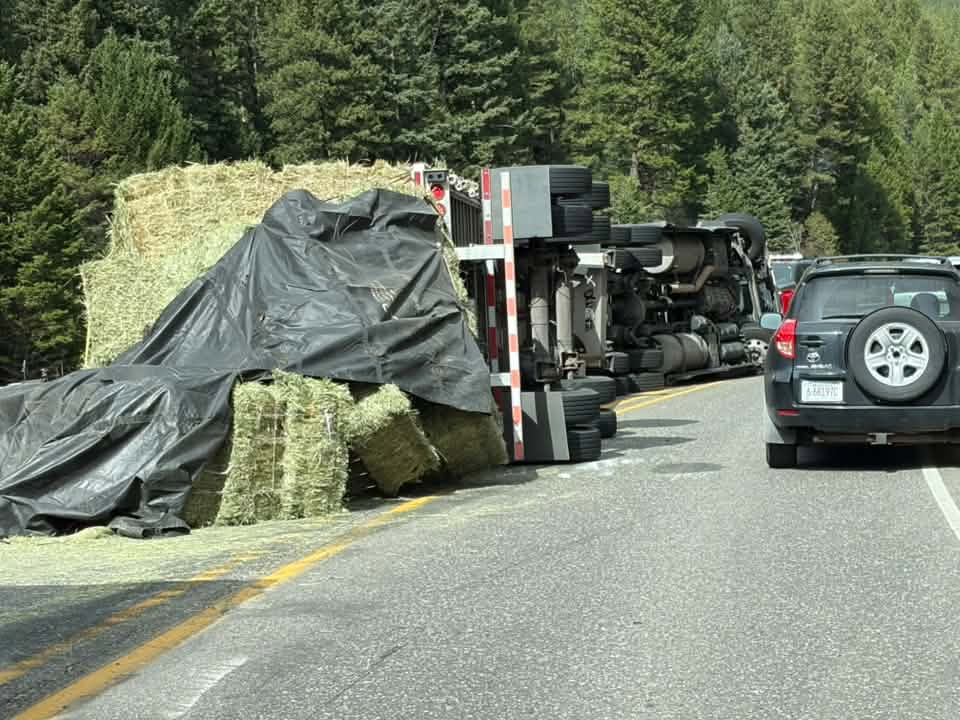
The app saw it at 12:03, five minutes before the highway patrol stamped its own dispatch time. It was on the Conditions screen of every phone at the next refresh, and I had an alert on my phone a minute later.
Drivers saw it too. The first “accident” report came from inside the dead zone eleven minutes later. It couldn’t reach us until that driver got signal again, but it came. Nine reports over the day, most of them within a mile of the wreck or on the queue behind it.
And people came looking. About three times as many phones opened the app that day as on a normal day. That’s the whole bet with this thing: when something happens in the canyon, people want one place to check.
Where it went wrong
The highway patrol’s record described the wreck as a no-injury crash. That’s accurate about the people, and it says nothing about the road. The app treated “no injury crash” as a slowdown: yellow, and no push alert. Montana DOT’s 511 feed had it right at 12:28, “FULL BLOCKAGE; PREPARE TO STOP,” but the app wasn’t using 511 to decide anything.
So at 1:43, after the sheriff’s office said it would take several hours to clear, I sent a push notification by hand. It reached four phones.
At 3:18 the highway patrol closed its record. The trooper was done. The wrecker, the trailer, and a lane full of hay were not. The app took the trooper’s notification literally and stood down.
The worst of the day came after that. From about a quarter to five until after 8, northbound traffic backed up ten miles to the Big Sky turnoff. One driver took 3 hours and 24 minutes to get through. A Facebook post that night summed it up: “Left Big Sky at 5:40pm got to Gateway at 9pm.”
At 5:31 there was a second, smaller crash at Spanish Creek, milepost 68. The app pushed that one automatically to red, in two seconds. Twenty-seven minutes later the highway patrol cleared it, and the app sent: “Highway patrol has cleared the incident. US-191 is reported open.”
To three drivers. Who were sitting in the queue.
Nothing had measured “open.” The app had a rule never to say a number it didn’t measure, and then it said a word it didn’t measure. My error, and the dumbest thing the app said all day.
What’s different now
These changes are on the server, so they reach every phone already. No update needed.
The app doesn’t just say “open” anymore. It says what it actually knows: “Highway patrol has closed its incident near Greek Creek,” or “MDT no longer reports blocked lanes near Greek Creek.”
The warning stays up while the road still looks bad. If drivers are still crawling through, still stopped, or still reporting trouble near the spot, the canyon stays red after the trooper leaves, for up to three hours.
MDT 511 counts now. When 511 reports blocked lanes on 191, the app goes red and pushes on its own, whatever the dispatch code says.
A “slowdown” code plus a second witness becomes a blockage. Had this been in place on the 22nd, the push would have gone out at about 12:30 instead of my hand-sent one at 1:43.
I can push from my phone in one tap, and a manual alert can stay up until I clear it rather than expiring on a guess. On the 22nd my alert expired at 7:00 while the road was still one lane.
I replayed the 22nd through the new rules. The push goes out at 12:30, nothing claims the road is open while the evening queue builds, and the all-clear comes once the traffic actually goes quiet.
What’s coming next
Satellite. If your phone plan includes carrier satellite service (T-Mobile’s T-Satellite and similar), the next version of the app can use it from inside the dead zone. The data capability on satellite is very limited, so only the small stuff: checking the canyon’s status, sending a report, and checking in on where you are. Whole drives still wait for real signal. iPhone will ask you once before the app uses the satellite link. Coverage is up to the carrier and the canyon walls block a lot of sky, so it won’t always connect. But a driver stopped at the wreck could tell the rest of us right away, instead of whenever they get out.
Phones that already have signal inside the canyon will report in while they drive, instead of waiting until they come out the other side. On the 22nd, the queue was sitting on phones for over an hour before anyone could see it. While investigating how to improve from this accident I found that there are a few people who have continuous data through the dead zone, presumably Starlink, so that will start adding real time information.
The app will ask whether you want alerts the first time it shows you something blocking a road you follow, which is exactly when you’d want to say yes. Right now push alerts are a switch in Settings that hardly anyone has found.
Support back to iOS 18 for people who haven’t been able to update.
Turn on alerts
If you only do one thing after reading this: open the app, go to Settings, and turn on push alerts for 191. The four phones that got my message on the 22nd were the only ones that heard about the closure without having to open the app and look.
And spread the word. Every driver with the app makes the picture better for the rest of us, especially on the days it matters most.